— Deutscher Text folgt unten —
Yesterday our research trip turned into a rescue mission for some time. What had happened? Maybe you remember the heavy storm we reported about at the beginning of our trip, which forced us to change our work area. It was exactly this storm that damaged a long-term ocean observation facility of our partners from the British National Oceanography Centre (NOC) west of Ireland.
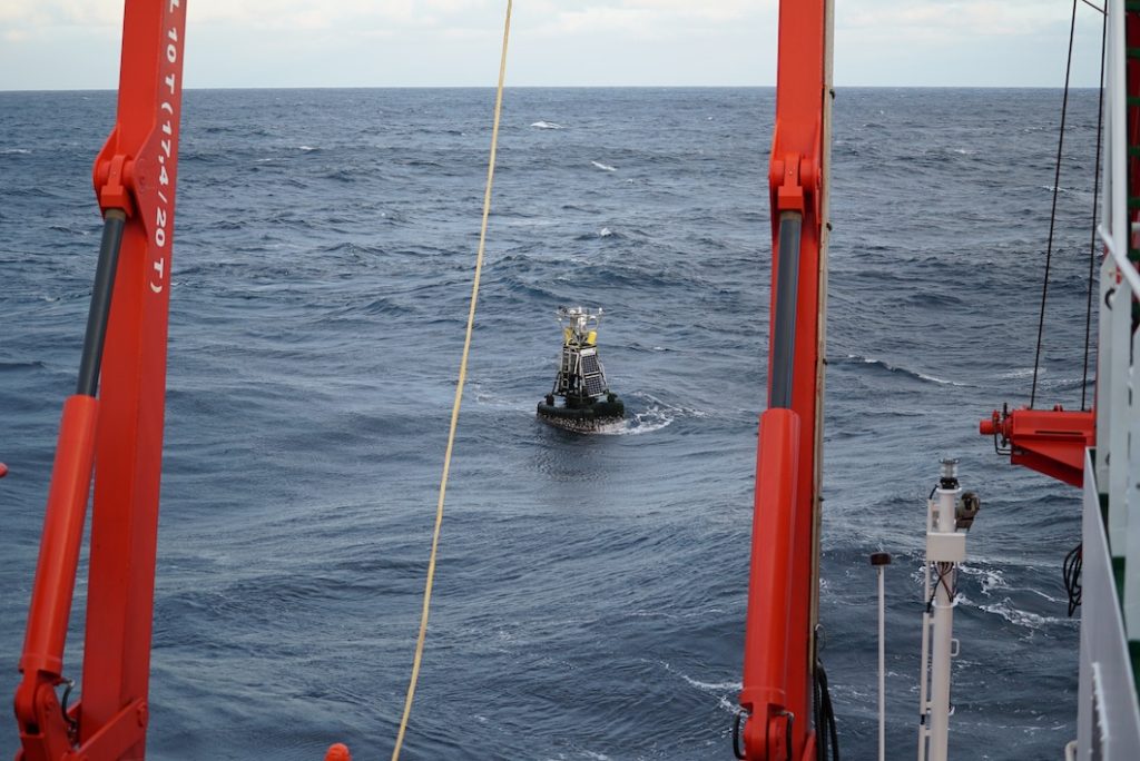
The more than 6 meter-high buoy, which formed the surface unit of this observatory, was ripped off the mooring by waves up to ten meters high and subsequently drifted uncontrolled in the Atlantic Ocean. Of course we helped our partners. But before we get to the dramatic hours of the recovery, let’s start at the beginning. Here is a protocol of the events:
- May 2020: We discuss the plan for our expedition MSM96 with the colleagues from the NOC. The NOC draws our attention to the fact that they run the Porcupine Abyssal Plain Observatory (PAP) with a surface buoy close to the planned area of our activities. In our plans we take into account a safety distance to the PAP
- 10 October 2020: We start the expedition MSM96 and sail to our northern working area 100 nautical miles east of the PAP.
- 27 October 2020: The NOC notifies the scientific community that the PAP-buoy has been ripped of its mooring.
- 28 October 2020: The GEOMAR Ship Coordination and the German Research Vessel Control Center at the University of Hamburg discuss that the RV METEOR and the RV MARIA. S. MERIAN are in the vicinity of the drifting buoy.
- 29. October 2020: The NOC submits technical specifications of the buoy to clarify whether MARIA S. MERIAN or METEOR are capable of recovering it.
- 29. October 2020: The ships’ crews and chief scientists on board are informed. The MARIA S. MERIAN’s crew reports that it has experience with such buoys. The buoy drifts through our northern working area
- 31. October 2020: We on board the MERIAN are planning the final work in our southern working area to catch an optimal weather window for the transit and recovery of the buoy.
- 01 November 2020: We receive daily position updates from the colleagues of the NOC. The buoy is drifting towards the Exclusive Economic Zone of Ireland.
- 02 November 2020: A salvage operation in the Irish EEZ becomes more and more probable. However, we do not have a research permit there. The diplomatic channels are activated.
- 03 November 2020: We contact colleagues at the Irish Marine Institute to raise awareness of the emergency for the incoming diplomatic request.
- 04 November 2020: In the morning we receive the formal diplomatic approval of the Irish Department of Foreign Affairs. A procedure that normally takes six months was carried out by ship, control center, Foreign Office, Embassy, Foreign Ministry and three research institutes within 2 days. This is what I call European cooperation!
- 05 November 2020 (at night): Due to the weather the buoy has left Irish waters again 😊 In international waters we are allowed to salvage it anyway. The unlighted (!) buoy appears on the radar.
- 05 November 2020, 06.30 a.m.: We see the buoy in the spotlight.
- 05 November 2020, 08.00 a.m.: The recovery operation begins
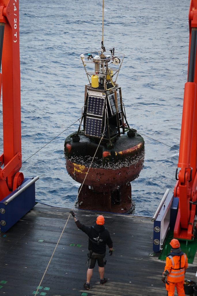
- 05 November 2020, 08.30 a.m.: Buoy is on the hook of the stern crane of the MERIAN.
- 05 November 2020, 08.40 a.m.: The PAP buoy is safely on deck. She is clearly affected by the two years of operation and probably by the storm that tore her loose. However, we made it.
On 10 November we will arrive in Emden. Then we will prepare the buoy and the measuring instruments attached to it for transport to Southampton. For me, this is my first expedition as a chief scientist – and the recovery operation was an exciting experience for me. But marine research is an international business, and without good partners and friends, we won’t get anywhere in the vast oceans.
Nachbarschaftshilfe
Gestern verwandelte sich unsere Forschungsfahrt für einige Zeit in eine Rettungsmission. Was war passiert? Vielleicht erinnert Ihr Euch an den schweren Sturm, von dem wir am Anfang unserer Fahrt berichtet haben und der uns dazu zwang, das Arbeitsgebiet zu wechseln. Genau dieser Sturm hat eine Langzeit-Ozeanbeobachtungseinrichtung unserer Partner vom britischen National Oceangraphy Centre (NOC) westlich von Irland beschädigt. Die mehr als 6 Meter hohe Boje, die die Oberflächeneinheit dieses Observatoriums bildete, riss bei bis zu zehn Meter hohen Wellen ab und trieb anschließend unkontrolliert im Atlantik. Und wir waren das einzige Schiff in der Nähe, dass Hilfe leisten konnte. Klar haben wir unseren Partnern geholfen. Aber bevor wir zu den dramatischen Stunden der Bergung kommen, fangen wir doch am Anfang an. Hier ein Protokoll der Ereignisse:
- Mai 2020: Wir besprechen mit Kollegen des NOC den Plan für unsere Expedition
MSM96. Das NOC macht uns darauf aufmerksam, dass sie nahe
unseres geplanten Arbeitsgebiet das Porcupine Abyssal Plain Observatory (PAP) mit einer Oberflächenboje betreiben. Wir planen so, dass wir uns vom PAP fernhalten, um es nicht zu beschädigen. - 10.10.2020: Wir beginnen die Ausfahrt MSM96 und steuern unser nördliches
Arbeitsgebiet 100 Seemeilen östlich des PAP an. - 27.10.2020: Das NOC benachrichtigt die Wissenschafts-Community, dass sich die PAP-
Boje losgerissen hat. - 28.10.2020: Die GEOMAR-Schiffskoordination und die Leitstelle Deutsche Forschungsschiffe an der Universität Hamburg besprechen, dass die FS METEOR und die FS MARIA. S. MERIAN in der Nähe sind
- 29.10.2020: Das NOC übermittelt technischen Spezifikationen der Boje, um zu klären, ob MARIA S. MERIAN oder METEOR in der Lage sind, die Boje zu bergen
- 29.10.: Die Schiffe und Fahrtleitungen an Bord werden informiert. Die MARIA S. MERIAN
meldet, dass sie Erfahrung mit solchen Bojen hat. Die Boje treibt außerdem in unserem nördlichen Arbeitsgebiet - 31.10.2020: Wir an Bord der MERIAN planen die letzten Arbeiten in unserem südlichen Arbeitsgebiet, um ein optimales Wetterfenster für den Transit und die Bergung der Boje abzupassen.
- 01.11.2020: Wir bekommen tägliche Positionsupdates von den Kollegen des NOC. Die Boje treibt in Richtung der Ausschließlichen Wirtschaftszone Irlands.
- 02.11.2020: Eine Bergung in der AWZ wird immer wahrscheinlicher. Allerdings haben wir dort keine Forschungsgenehmigung. Die diplomatischen Kanäle werden aktiviert.
- 03.11.2020 Wir nehmen Kontakt mit Kollegen am Marine Institute in Irland auf um auf die Dringlichkeit der diplomatischen Anfrage hinzuweisen
- 04.11.2020: Morgens erhalten wir die Zustimmung des irischen Außenministeriums. Ein Prozedere, dass normalerweise sechs Monate dauern kann, wurde durch Schiff, Leitstelle,
Auswärtiges Amt, Botschaft, Außenministerium und drei Forschungsinstitute innerhalb von 2 Tagen erreicht. Das nenne ich europäische Zusammenarbeit! - 05.11.2020 (nachts): Aufgrund des Wetters hat die Boje irische Gewässer wieder verlassen 😊 In internationalen Gewässern dürfen wir sie ohnehin bergen. Die unbeleuchtete(!) Boje taucht auf dem Radar auf.
- 05.11.2020, 06.30 Uhr: Wir sehen die Boje im Scheinwerferlicht.
- 05.11.2020, 08.00 Uhr: Das Bergemanöver beginnt
- 05.11.2020, 08.30 Uhr: Boje am Haken des Heckkran der MERIAN.
- 05.11.2020, 08.40 Uhr: Die PAP-Boje steht sicher an Deck. Sie ist deutlich mitgenommen von den zwei Jahren im Einsatz und vermutlich von dem Sturm, der sie losgerissen hat. Geschafft.
Am 10.11. werden wir in Emden einlaufen und die Boje und die daran befestigten Messgeräte für den Transport nach Southampton vorbereiten. Für mich ist das die erste Expedition als Fahrtleiter – und die Bergeaktion war dabei zusätzlich aufregend. Aber Meeresforschung ist ein internationales Geschäft und ohne gute Partner und Freunde kommen wir in den weiten der Ozeane alle nicht weiter. Gegenseitige Hilfe ist selbstverständlich.