[Deutsche Version unten]
Weekly Report SO289
Progress: We have had a successful week, following our unplanned detour to Tahiti. We commenced sampling again on March 23 and have been able to conduct daily station occupations with CTD casts and in situ pump deployments (Fig. 1). The weather has been variable with winds up to force 6-7 Beaufort, but mostly below 4 Beaufort.
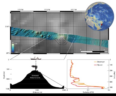
Following our diversion to Tahiti, we decided to follow a cruise track that was more northerly (26°10S) than initially planned, in order to save steaming time on our way to New Caledonia; station spacing was 4 degrees. The chosen track allowed us to sample in the international waters between the EEZs of New Zealand and Tonga (Fig. 2). The narrow gap between these EEZs facilitated us to sample the Kermadec-Tonga Trench (station 39) and also an underwater volcanic system on the ridge (station 40). Fig. 3 shows the position of station 40 on a global map, with the multibeam data over the Monowai volcano cone, and also the vertical profile of turbidity at station 40. The underwater volcanic inputs are visible at depths between the seafloor (530 m) and ca. 300 m depth at this station. Previous cruises that worked in the vicinity of station 40, have noted seismic activities. We did not observe this, but we spotted large amounts of pumice (derived from volcanic eruptions) floating on the surface of the ocean. We also spotted a lot Trichodesmium which is a filamentous diazotroph (organism that fixes di-nitrogen gas from the atmosphere; like the legumes in your garden). Trichodesmium flourish in regions with low nitrate concentrations and elevated dissolved Fe concentrations as it has a high iron requirement for its enzyme system (Nitrogenase) that facilitates the nitrogen gas fixation. The region may well receive enhanced iron inputs from pumice, Australian desert dust deposition, hydrothermal inputs and run-off from islands. Our analysis of the samples after the cruise will allow us to link Trichodesmium abundance with surface water nutrient and iron concentrations.
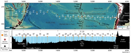
The last 4 stations of cruise SO289 are conducted in the South Fiji Basin (Fig. 2), which is impacted by hydrothermal inputs in addition to a range of inputs from continental run-off and sediments. The last station (station 44) was occupied in the early morning of April 4. Following this station, we started packing up and loading our containers. A threat of a tropical cyclone is forcing us to pack swiftly to allow us flexibility in arriving in the port of Noumea in the coming days, before flying home on April 9. The start of our cruise was full of challenges, with a delay of nearly 5 days, and now the end of the cruise will also be impacted by the arrival of the tropical cyclone. Who said that research cruises are a jolly?!
Mercury observations: Mercury (Hg) is a natural but also a very toxic element, and the various chemical Hg species can have detrimental impacts on marine ecosystems. There is a lack of understanding of Hg sources, speciation, cycling, and distributions in marine systems. The atmospheric component dominates the global transport of Hg and has a significant influence on oceanic Hg fluxes. Natural sources of Hg include geologically active systems such as volcanoes and hydrothermal vents. Coal burning, cement manufacturing and other industrial practices form the majority of anthropogenic Hg emissions to the atmosphere and oceans, and these have persistently increased over the last 5 decades.
On cruise SO289, Kati Gosnell and Alina Kleindienst perform an ocean basin wide study in the South Pacific Ocean to assess Hg sources, speciation and cycling in one of the remotest ocean regions on our planet. The analysis for total Hg concentrations on SO289 is conducted on board by Kati and Alina. The data is immediately available and is showing the importance of various sources along the section.
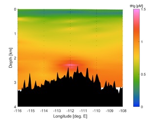
The Southern Pacific Ocean is host to many active seismic margins and hydrothermal vent fields and therefore subject to various natural Hg inputs. However, there is a paucity of Hg data for this region, and hence our understanding of Hg sources and behaviour is poorly constrained for this basin. Figure 4 shows enhanced total Hg concentrations at a depth of about 2500 m at station 22 in a hydrothermal plume emanating from the East Pacific Rise. The East Pacific Rise runs from the North to the South Pacific Ocean and Hg inputs to the deep ocean of its hydrothermal systems are likely to make an important contribution to deep ocean Hg concentrations.
RV SONNE at sea 25°45 S/174°2 E
Eric Achterberg
GEOMAR Helmholtz Centre for Ocean Research Kiel/University of Kiel
Beobachtungen von Monowai Vulkankegel und Quecksilber im Südpazifik
Wochenbericht für SO289
Fortschritte: Nach unserem ungeplanten Abstecher nach Tahiti haben wir eine erfolgreiche Woche hinter uns. Wir haben am 23. März wieder mit der Beprobung begonnen und konnten tägliche Stationsbesetzungen mit CTD-Einsätzen und In-situ-Pumpeinsätzen durchführen (Abb. 1). Das Wetter war wechselhaft mit Windstärken bis zu 6-7 Beaufort, aber meist unter 4 Beaufort.
Nach unserer Umleitung nach Tahiti entschieden wir uns für einen nördlicheren Kurs (26°10S) als ursprünglich geplant, um auf dem Weg nach Neukaledonien Dampfzeit zu sparen; der Stationsabstand betrug 4 Grad. Die gewählte Route ermöglichte es uns, in den internationalen Gewässern zwischen den EEZs von Neuseeland und Tonga Proben zu nehmen. Die schmale Lücke zwischen diesen EEZs ermöglichte uns die Beprobung des Kermadec-Tonga-Grabens (Station 39) und eines Unterwasservulkansystems auf dem Kamm (Station 40) (Abb 2). Abb. 3 zeigt die Position der Station 40 auf einer globalen Karte mit den Fächerecholotdaten über dem Monowai-Vulkankegel sowie das vertikale Profil der Trübung an Station 40. Die vulkanischen Unterwassereinträge sind an dieser Station in Tiefen zwischen dem Meeresboden (530 m) und ca. 300 m Tiefe sichtbar. Bei früheren Fahrten in der Nähe von Station 40 wurden seismische Aktivitäten festgestellt. Bei uns war das nicht der Fall, aber wir entdeckten große Mengen von Bimsstein (der aus Vulkanausbrüchen stammt), der auf der Meeresoberfläche schwamm. Außerdem entdeckten wir eine Menge Trichodesmium, ein fadenförmiges Diazotroph (Organismus, der Stickstoff aus der Atmosphäre bindet; wie die Hülsenfrüchte in Ihrem Garten). Trichodesmium gedeiht in Regionen mit niedrigen Nitratkonzentrationen und hohen Konzentrationen an gelöstem Eisen, da es einen hohen Eisenbedarf für sein Enzymsystem (Nitrogenase) hat, das die Stickstoffgasfixierung ermöglicht. Möglicherweise erhält die Region einen erhöhten Eiseneintrag durch Bimsstein, Ablagerung von australischem Wüstenstaub, hydrothermale Einträge und Abfluss von Inseln. Unsere Analyse der Proben nach der Fahrt wird es uns ermöglichen, die Häufigkeit von Trichodesmium mit den Nährstoff- und Eisenkonzentrationen im Oberflächenwasser in Verbindung zu bringen.
Die letzten vier Stationen der Fahrt SO289 werden im Süd-Fiji-Becken (Abb. 2) durchgeführt, das neben einer Reihe von Einträgen durch kontinentale Abflüsse und Sedimente auch durch hydrothermale Einträge beeinflusst wird. Die letzte Station (Station 44) ist am frühen Morgen des 4. April gemacht. Nach dieser Station sind wir angefangen mit dem Zusammenpacken und Beladen unserer Container. Ein drohender tropischer Wirbelsturm zwingt uns zum schnellen Packen, damit wir in den nächsten Tagen flexibel im Hafen von Noumea ankommen, bevor wir am 9. April nach Hause fliegen. Der Beginn unserer Fahrt war mit einer Verspätung von fast 5 Tagen voller Herausforderungen, und nun wird auch das Ende der Fahrt durch das Eintreffen des tropischen Wirbelsturms beeinträchtigt werden. Wer sagt denn, dass Forschungsfahrten ein Vergnügen sind?
Beobachtungen zu Quecksilber: Quecksilber (Hg) ist ein natürliches, aber auch ein sehr giftiges Element, und die verschiedenen chemischen Hg-Arten können schädliche Auswirkungen auf marine Ökosysteme haben. Es mangelt an Kenntnissen über die Hg-Quellen, die Speziation, den Kreislauf und die Verteilung von Hg in marinen Systemen. Die atmosphärische Komponente dominiert den globalen Transport von Hg und hat einen erheblichen Einfluss auf die ozeanischen Hg-Flüsse. Zu den natürlichen Hg-Quellen gehören geologisch aktive Systeme wie Vulkane und hydrothermale Schlote. Kohleverbrennung, Zementherstellung und andere industrielle Verfahren machen den Großteil der anthropogenen Hg-Emissionen in die Atmosphäre und die Ozeane aus, und diese haben in den letzten fünf Jahrzehnten stetig zugenommen.
Auf der Fahrt SO289 führen Kati Gosnell und Alina Kleindienst eine ozeanbeckenweite Studie im Südpazifik durch, um die Hg-Quellen, die Speziation und den Kreislauf in einer der entlegensten Ozeanregionen unseres Planeten zu bewerten. Die Analyse der Gesamt-Hg-Konzentration auf SO289 wird von Kati und Alina an Bord durchgeführt. Die Daten sind sofort verfügbar und zeigen die Bedeutung der verschiedenen Quellen entlang der Strecke.
Der südliche Pazifik beherbergt viele aktive seismische Ränder und hydrothermale Schlotfelder und ist daher verschiedenen natürlichen Hg-Einträgen ausgesetzt. Es gibt jedoch nur wenige Hg-Daten für diese Region, so dass unser Verständnis der Hg-Quellen und des Verhaltens in diesem Becken nur unzureichend eingeschränkt ist. Abbildung 4 zeigt erhöhte Gesamt-Hg-Konzentrationen in einer Tiefe von etwa 2500 m an Station 22 in einer hydrothermalen Wolke, die vom East Pacific Rise ausgeht. Die East Pacific Rise erstreckt sich vom Nord- bis zum Südpazifik, und die Hg-Einträge in den tiefen Ozean aus seinen hydrothermalen Systemen dürften einen wichtigen Beitrag zu den Hg-Konzentrationen im tiefen Ozean leisten.
RV SONNE auf See 25°46 S/173°3E
Eric Achterberg GEOMAR Helmholtz-Zentrum für Ozeanforschung Kiel/Universität Kiel