Weekly Report / Wochenbericht SO289
(Deutsche Version unten)
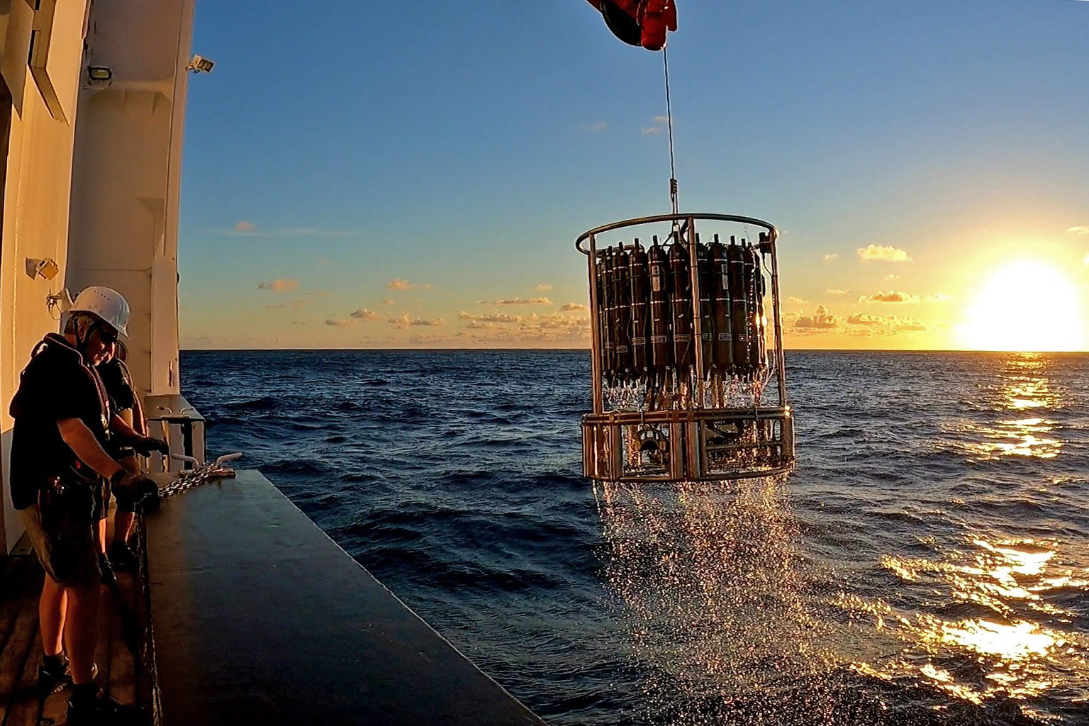
Progress: We have had a successful week, with daily station occupations with smooth CTD casts and in-situ pump deployments. We have made steady progress west towards Noumea along our 31.5°S latitude cruise track. We have speeded up progress by combining our CTD casst with in situ pump deployments at the super stations, which occur every fourth station. At the superstations we take samples for a range of isotopes (Pb, Fe, Cd, Zn, Nd, Ba, Si, Th Pa) and also collect particles on filters in the water column using a total of eleven in situ pumps. The pumps are deployed up to a depth of 2500 metres and pump for a period of three hours before being recovered.
The weather has been kind to us, but the last few days the wind has increased, and so have the waves. Today we had six to seven Beaufort winds and waves up to four metres. This is no problem for the deployments of the CTD frames on the SONNE, but we postponed the in situ pump deployment until tomorrow when winds will be down to two to three Beaufort.
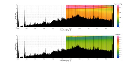
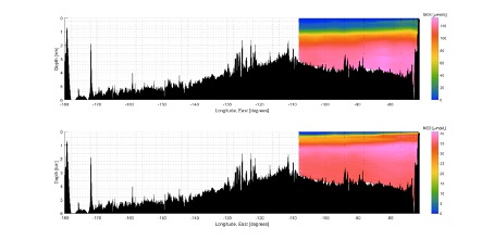
Nutrient and dissolved oxygen observations. Andre Mutzberg with assistance by Tabea von Keitz and Lea Blum are very busy in the SONNE lab with the analyses of nutrients (auto analyser) and oxygen (Winkler titrations), and also working up the data. Fig. 2 shows a section of oxygen, salinity, silicic acid and nitrate along our cruse track. The key feature in the oxygen section are the low oxygen waters (less than 50 micromole per kilogramme) emanating from the Chilean shelf. The oxygen depletion is caused by sinking of large amounts of phytoplankton debris that are remineralised at depth with an associated consumption of oxygen. Strong phytoplankton blooms occur on the eastern boundary of the South Pacific due to upwelling of deep nutrient rich waters. The salinity section indicates fresher surface waters towards the Chilean shelf, with increases in surface water salinity towards the centre of the South Pacific gyre, as a result of net evaporation over precipitation. The nutrient sections show very strong depletion in surface waters due to uptake by phytoplankton and low supply rates, with nutrient enrichment in subsurface waters related to remineralisation of sinking organic particles with a release of nutrients, and also the presence of Antarctic Intermediate Waters (800-1500 metres).
East Pacific Rise: The South Pacific hosts large underwater volcanoes and hydrothermal vents along the East Pacific Rise, an underwater ridge in the middle of the ocean situated between spreading tectonic plates where magma from the earth’s mantle rises. The vents emit hot fluids into the deep ocean at about 2500 metres water depth. They contain high concentrations of iron and other elements that are required by phytoplankton for their growth. The plumes of iron in the deep waters are thought to be transported southwards and to reach the surface waters in the Southern Ocean, which is the largest region in the world’s ocean where phytoplankton growth is limited by iron. The expedition will assess the hydrothermal iron inputs and use tracers and modelling approaches to determine their impact on Southern Ocean productivity.
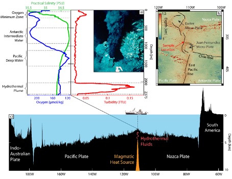
In hydrothermal systems, seawater penetrates the permeable oceanic crust, and is heated during its passage down. The seawater will react with basalt that overlies the rising magma at depths of one to two kilometres (Fig. 3c), and rises and is expulsed as hot altered seawater at the seafloor (Fig. 3a). The emitted fluids are acidic, sulfur-rich and enriched in metals like iron, manganese, copper. Iron sulfide and oxide particles will rapidly form in the buoyant plume upon mixing with oxygen rich deep ocean waters, and a large part of the particles will sink. The plume will rise a few hundred meters above the seafloor before being transported away from the vent site by deep ocean currents. A fraction of the dissolved metals will remain in solution, and ultimately reach the surface ocean
On Wednesday March 9, we conducted a super station on the East Pacific Rise at 31.5°S, 111.9°W, just north of the Juan Fernandez microplate (Fig 3b). The EPR station was positioned between the Pacific and Nazca tectonic plates. The region is well known for its hydrothermal plumes, and we were very much looking forward to finding them.
The team on board identified a very distinct plume in the signal of the turbidity sensor that measures particle concentrations in the water column (Fig. 3a). The particles will be made up of iron sulfides and iron oxides, with other metals adsorbed onto them. In-situ water pumps were deployed at the stations and collected the iron-rich particles in the hydrothermal plume at a depth of 2200 metres. The filters from the pumps will be brought back to land for chemical, biological and mineralogical (EDX and synchrotron) analysis.
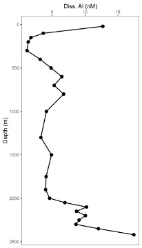
On board of SONNE, GEOMAR PhD student Te Liu is conducting measurements of dissolved aluminium in the water column. Results for the station above the hydrothermal vent at the EPR is shown in Figure 4, and shows enhanced concentrations in surface waters associated with atmospheric inputs of aluminium (derived from lithogenic dust deposition). The profile also shows increased concentration towards the seafloor which are associated with inputs from the hydrothermal systems, and perhaps also release from seafloor sediments.
Beprobung der Hydrothermalfahne auf dem Ostpazifikanstieg und erste Ergebnisse unserer Analyse an Bord
Fortschritte: Wir hatten eine erfolgreiche Woche mit täglichen Stationsbesetzungen mit reibungslosen Einsätzen von CTD- und In-situ-Pumpen. Wir haben unserem Fahrtweg entlang des 31,5°S Breitengrades stetig nach Westen in Richtung Noumea fortgesetzt und kommen nun schneller voran, da wir die CTD-Einsätze mit den Pumpeinsätzen an den “Superstationen” kombiniert haben, die an jeder vierten Station stattfinden. An den “Superstationen” nehmen wir Proben für eine Reihe von Isotopen (Pb, Fe, Cd, Zn, Nd, Ba, Si, Th Pa) und sammeln auch Partikel auf Filtern in der Wassersäule mit insgesamt elf In-situ-Pumpen. Die Pumpen werden bis zu einer Tiefe von 2500 Metern eingesetzt und pumpen drei Stunden lang, bevor sie wieder eingeholt werden.
Das Wetter hat es gut mit uns gemeint, aber in den letzten Tagen hat der Wind zugenommen, und damit auch die Wellen. Heute hatten wir sechs bis sieben Beaufort Wind und Wellen bis zu vier Metern Höhe. Das ist kein Problem für den Einsatz der CTD-Rahmen auf der Sonne, aber wir haben den Einsatz der In-situ-Pumpe auf morgen verschoben, wenn der Wind auf zwei bis drei Beaufort abgeflaut sein wird.
Beobachtungen von Nährstoffen und gelöstem Sauerstoff: Andre Mutzberg ist mit Unterstützung von Tabea von Keitz und Lea Blum im SONNE-Labor mit der Analyse der Nährstoffe (Autoanalysator) und des Sauerstoffs (Winkler-Titrationen) und der Aufbereitung der Daten beschäftigt. Abb. 2 zeigt einen Schnitt von Sauerstoff, Salzgehalt, Kieselsäure und Nitrat entlang unserer Krustenstrecke. Das Hauptmerkmal im Sauerstoffabschnitt sind die sauerstoffarmen Gewässer (weniger als 50 Mikromol pro Kilogramm), die vom chilenischen Schelf ausgehen. Die Sauerstoffverarmung wird durch das Absinken großer Mengen von Phytoplankton-Resten verursacht, die in der Tiefe remineralisiert werden und dabei Sauerstoff verbrauchen.
An der östlichen Grenze des Südpazifiks kommt es aufgrund des Auftriebs von nährstoffreichem Tiefenwasser zu starken Phytoplanktonblüten. Der Salzgehalt zeigt, dass das Oberflächenwasser in Richtung des chilenischen Schelfs süßer ist und der Salzgehalt des Oberflächenwassers in Richtung des Zentrums des südpazifischen Wirbels ansteigt, was auf die Nettoverdunstung gegenüber den Niederschlägen zurückzuführen ist. Die Nährstoffprofile zeigen eine sehr starke Verarmung der Oberflächengewässer aufgrund der Aufnahme durch das Phytoplankton und geringer Zufuhrraten, während die Nährstoffanreicherung in den unterirdischen Gewässern mit der Remineralisierung sinkender organischer Partikel und der Freisetzung von Nährstoffen zusammenhängt, sowie mit dem Vorhandensein antarktischer Zwischengewässer (800-1500 Meter).
Ostpazifischer Rücken: Im Südpazifik gibt es große Unterwasservulkane und hydrothermale Schlote entlang des Ostpazifischen Rückens, eines Unterwasserrückens in der Mitte des Ozeans zwischen sich auseiander bewegenden tektonischen Platten, wo Magma aus dem Erdmantel aufsteigt. Aus den Schloten strömen heiße Flüssigkeiten in die Tiefsee in etwa 2500 Metern Wassertiefe. Sie enthalten hohe Konzentrationen von Eisen und anderen Elementen, die das Phytoplankton für sein Wachstum benötigt. Es wird angenommen, dass die Eisenfahnen in der Tiefe nach Süden transportiert werden und das Oberflächenwasser im Südlichen Ozean erreichen, der größten Region des Weltozeans, in der das Wachstum des Phytoplanktons durch Eisen begrenzt wird. Auf der Expedition werden die hydrothermalen Eiseneinträge bewertet und mit Hilfe von Tracern und Modellierungsansätzen ihre Auswirkungen auf die Produktivität des Südlichen Ozeans ermittelt.
In hydrothermalen Systemen dringt Meerwasser in die durchlässige ozeanische Kruste ein und wird auf seinem Weg nach unten erhitzt. Das Meerwasser reagiert mit Basalt, der das aufsteigende Magma in einem bis zwei Kilometern km Tiefe überlagert (Abb. 3c), steigt auf und wird als heißes, verändertes Meerwasser am Meeresboden ausgestoßen (Abb. 3a). Die austretenden Fluide sind sauer, schwefelhaltig und reich an Metallen wie Eisen, Mangan und Kupfer. Bei der Vermischung mit sauerstoffreichem Tiefenwasser bilden sich in der Auftriebsfahne rasch Eisensulfid- und -oxidpartikel, von denen ein großer Teil absinkt. Die Fluid-Fahne steigt einige hundert Meter über den Meeresboden auf, bevor sie von den Tiefseeströmungen vom Austrittsort fortgetragen wird. Ein Teil der gelösten Metalle bleibt in Lösung und gelangt schließlich an die Meeresoberfläche.
Am Mittwoch, dem 9. März, führten wir eine Superstation auf dem Ostpazifik-Anstieg bei 31,5°S, 111,9°W durch, direkt nördlich der Juan-Fernandez-Mikroplatte (Abb. 3b). Die EPR-Station befand sich zwischen den tektonischen Platten des Pazifiks und der Nazca. Die Region ist für ihre hydrothermalen Plumes bekannt, und wir waren sehr gespannt darauf, diese zu finden.
Das Team an Bord konnte im Signal des Trübungssensors, der die Partikelkonzentration in der Wassersäule misst, einen sehr deutlichen Plume erkennen (Abb. 3a). Die Partikel bestehen aus Eisensulfiden und Eisenoxiden, an denen andere Metalle adsorbiert sind. An den Stationen wurden In-situ-Wasserpumpen eingesetzt, die die eisenhaltigen Partikel im hydrothermalen Plume in einer Tiefe von 2200 Metern auffangen. Die Filter aus den Pumpen werden zur chemischen, biologischen und mineralogischen (EDX und Synchrotron) Analyse an Land zurückgebracht.
An Bord der Sonne führt der GEOMAR-Doktorand Te Liu Messungen von gelöstem Aluminium in der Wassersäule durch. Die Ergebnisse für die Station oberhalb des hydrothermalen Schlots am EPR sind in Abbildung 4 dargestellt und zeigen erhöhte Konzentrationen im Oberflächenwasser, die mit atmosphärischen Aluminiumeinträgen (aus lithogenen Staubablagerungen) zusammenhängen. Das Profil zeigt auch erhöhte Konzentrationen zum Meeresboden hin, die mit Einträgen aus den hydrothermalen Systemen und vielleicht auch mit Freisetzungen aus den Sedimenten des Meeresbodens in Verbindung gebracht werden.
Eric Achterberg
Research vessel SONNE / Forschungsschiff SONNE 31.5°S/125.0°W
GEOMAR Helmholtz Centre for Ocean Research Kiel/University of Kiel