A new multi-facetted and interdisciplinary research project was recently launched at CVOO. The project investigates biogeochemical and ecological processes within mesoscale water masses, so-called eddies, in the vicinity of Cape Verde.
Since the establishment of CVOO, long-term mooring-based observations revealed a couple of unexpected biogeochemical and physical anomalies in the upper ocean. Strong hypoxic to even anoxic water masses just below the mixed layer were detected which could be related to the passage of mesoscale eddies at CVOO.

Left: Time-series record of sensor-based subsurface O2 measurements conducted continuously from 2006 on at the CV Ocean Observatory (CVOO) long-term mooring site. Shaded areas denote hypoxic and anoxic anomalies below the 40 µmol kg-1 threshold (dashed line). Right: A hydrographic section through the outer rim of the O2 anomaly in 2010, as recorded accidently by a glider.
Further evidence for the existence of these open-ocean phenomena was obtained by occasional observations conducted by autonomous mobile platforms, such as gliders and profiling floats.
The new project “Biogeochemistry and Ecology of Oxygen Depleted Eddies in the Eastern Tropical North Atlantic”, funded by the Kiel Excellence Cluster “Future Ocean”, makes use of 3 different methodological approaches in order to gain further insight into these eddies:
(i) satellite-based “sea surface height” data,
(ii) remote surveys with autonomous underwater glider, and
(iii) a full biogeochemical sampling survey with RV Islândia.
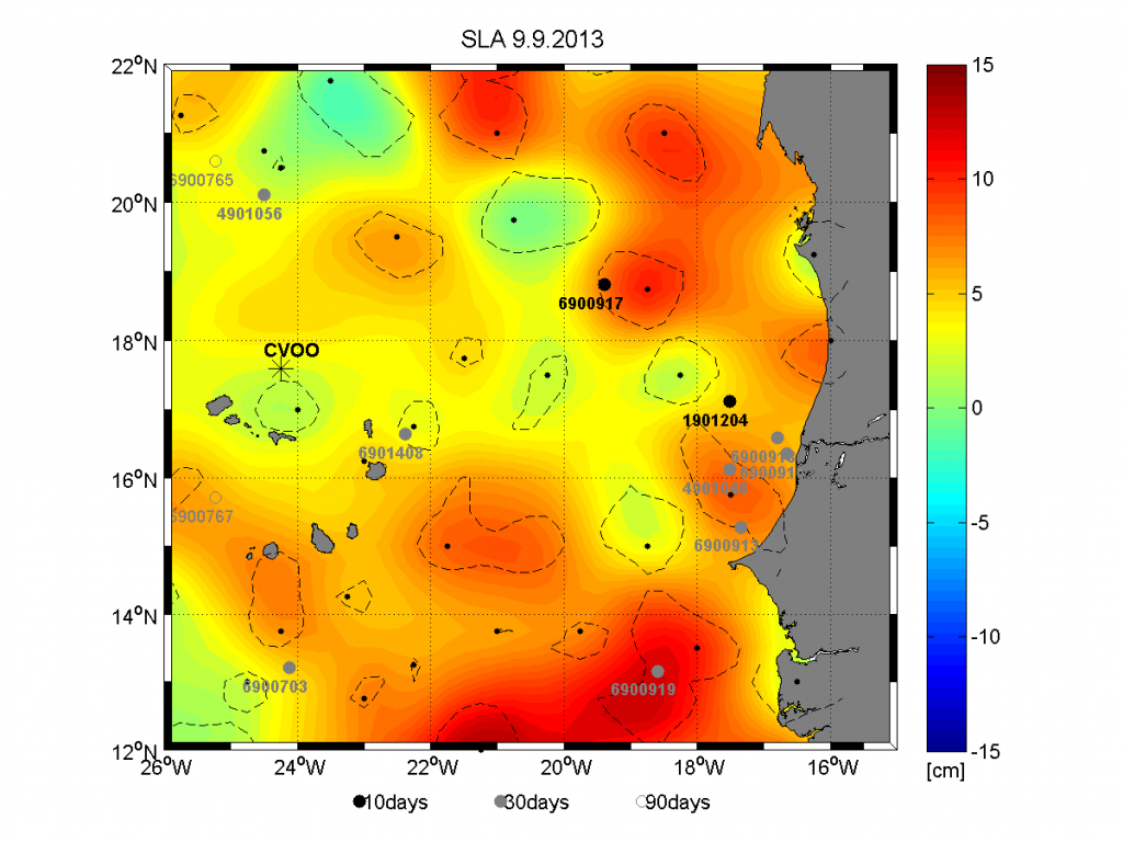
As a first project outcome a near-realtime satellite mapping tool was brought online that helps to identify potential eddy candidates and thus, better plan and conduct the remote and ship surveys (late 2013/early 2014). Online data can be accessed here.

Snapshot of sea level anomal (SLA) satellite data for the region between the Mauritanian coast and Cape Verde. Potential eddies are denoted with dashed lines and dots/numbers show locations of Argo floats in that area.

Statistical westward propagation of anticyclonic eddies within certain corridors (data between 2000 and 2011). Superimposed is the planned glider survey for the upcoming winter season. Picture modified from F. Schuette, master thesis.