By Gerd Schriever
Many different mineral resources can be found on the deep sea floor. Beside manganese nodules, manganese crusts, massive sulphides and rare earth elements are of commercial interest. The first manganese nodules were found in 1872 during the English “Challenger” expedition in the Atlantic Ocean but were quickly forgotten. During the late 1960s/early 1970s, large resources of manganese nodules were discovered in the Clarion Cliperton Fracture Zone (CCZ) north of the equator and several international commercial consortia were set up and started exploring the CCZ. Also Germany was involved – the Arbeitsgemeinschaft Mineralischer Rohstoffe (AMR) was member of the consortium Ocean Mining Incorporation (OMI). During the exploration and preliminary mining tests at the end of the 1970s scientists expressed their concerns about possible environmental impacts of future mining and in 1978 US-American scientists were asked to monitor the first test mining sites in the CCZ. In 1982 in several papers industry reported about future mining activities. Up to 65 mining collector systems were expected to work on the seafloor for more than 300 days per year and disturbing one square kilometre of the seafloor every day.
During the Deep-Sea Biology Symposium at Hamburg in 1985 Prof. Robert Hessler of the Scripps Institution of Oceanography (La Jolla/California) expressed his concerns about his results because he was not sure if his box corer really has sampled one of the mining tracks in nearly 5000 metres water depth. He underlined his concerns about impacting the deep-sea, a unique area we did not know much about at that time as video-guided sampling was not available. A German administrator, sitting in the audience, had listened to Prof. Hessler’s presentation and asked the scientists to design a project to monitor a pilot mining operation which was planned for the end of the decade. The South East Pacific Ocean was chosen because of political reasons and to avoid discussions and conflicts with the different consortia exploring their claims in the CCZ.
Prof. Hjalmar Thiel of the University of Hamburg took up this idea. He saw the chance for the assessment of possible environmental impacts of industrial intrusions in the deep sea far before these have started. The results of Prof. Hessler’s investigations on mining impacts and his own experiences from impact evaluations during the MESEDA-project (MEtalliferous SEDiments Atlantis) in the Red Sea in the late 1970s let him recognized that the results of these investigations did not allow an extrapolation to future commercial mining impacts. He started to design a large scale monitoring project and contacted the engineers responsible for the design and manufacturing the mining collector. He pointed out that only little information about the deep sea ecology existed and nobody knew what would happen when large areas of this environment would be destroyed. It was and still is unknown how long it would take for the recovery of the fauna after such large areal disturbances. It was speculated that it would take much longer than in shallow water areas – not only decades but perhaps more than hundred years.
The German research vessel SONNE was scheduled for January to end of March 1989 as platform for creating a disturbance and start a scientific monitoring of this experiment – first ideas of the DISCOL Experiment (from DISturbance and re-COLonization) were developed. In early 1988 the mining test was cancelled and the scientists were asked to come up with their own disturbance experiment. As we were not able to simulate mining it was necessary to create a disturbance comparable to the impact of future manganese nodule mining. This required
A: to remove the nodules from the seafloor surface and
B: to disturb the upper 15 to 20 centimetres of the sea-floor sediment
C: to create a sediment plume over the disturbed area by transporting sediment particles into the bottom water
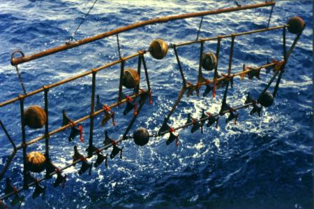
Thinking about how farmers plow their fields we started to design a device which was named plow-harrow. It was equipped with plow shares on both sides of the frame because we had no control on what side it would arrive on the seafloor, but we wanted to disturbed our experimental area.
Because of political reasons we were asked to do this experiment in the South Pacific Ocean and not in the manganese nodule belt of the CCZ. So in January 1989 we left the harbor of Balboa/Panama to start the first large scale impact experiment in the deep sea worldwide.
The first cruise was divided into four phases:
1. To find a suitable place close to a manganese nodule field that has been explored some years before by the German company Preussag. The area should be rather flat, providing a manganese nodule coverage of about five kilogrammes per square metre to be able to allow sampling for monitoring purposes.
2. To set up a circular DISCOL Experimental Area (DEA) and to start the baseline study of the deep sea fauna within this area.
3. To disturb the DEA with our plow harrow; for this we crossed the DEA 78 times to create a strong disturbance in the inner circle and a less intense disturbance in the outer circle. About 2.5 square kilometres of the total area of 11 square kilometres were directly impacted by the plow harrow and most of the rest was impacted by re-sedimentation.
4. Immediately after the disturbance we started to sample the same locations as during the baseline study (phase 2) to investigate the direct impact on the fauna.
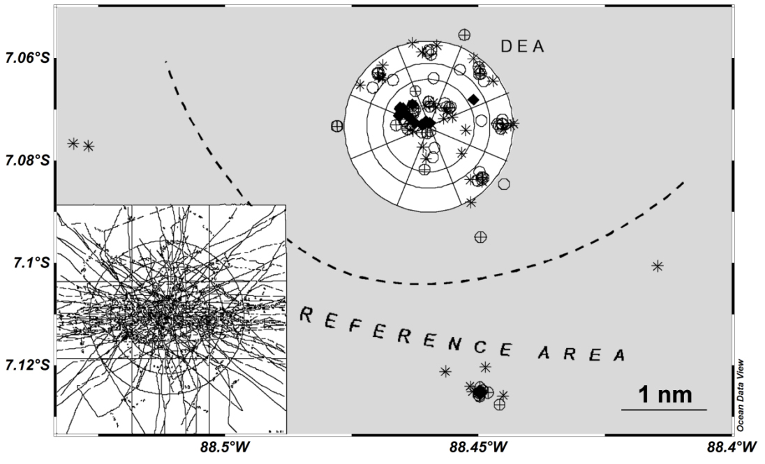
The working area of cruise SO242 (water depth approx. 4150 m). The symbols represent sampling positions during previous cruises to the DISCOL Experimental Area (DEA). White parts indicate the disturbed area. The insert shows disturbance tracks of the ‘deep-sea plough’ tows in 1989. The exact positions of stations will be defined based on the habitat maps obtained during SO242-1. Map after Borowski, 2001 (DSR II 48: 3809-3839).
The research vessel SONNE was equipped with a multibeam system to map the seafloor; it provided good information about the bottom topography to find a suitable place. Current meter chains were moored on seafloor for recording the direction and speed of currents. This was important to know because the disturbance stirred-up sediment into the water column which was transported away by current and re-sedimented in some distance. As we also wanted to sample a non impacted reference area for our long term monitoring the ocean floor observation system (OFOS) equipped with still camera and video systems was used and provided a first impression of the life at the sea floor. Box corer and multiple corer samples provided quantitative information of the different faunal size classes. Most of the specimens were new to science and had to be described, the belonged to a high number of different species; species diversity in the deep sea is much higher than in shallow waters.
It took us eight weeks to start the experiment. After the disturbance the plow-harrow tracks were visible on the OFOS video, the ocean floor was heavily disturbed and the larger animals like holothurians, crabs or sea anemones were gone. Most of the manganese nodules were also plowed under – our plow harrow has worked as expected and created a heavy disturbance certainly impacting the deep sea fauna. Back in the laboratories the samples had to be evaluated. Compared to the baseline study the number of individuals and species decreased in all size classes.
We returned to the DEA in September 1989, February 1992 and February/March 1996 to monitor the impact. In 1992 geological, geochemical and sedimentological investigations were added to the DISCOL-program. Beside scientists from the University of Hamburg colleagues from GEOMAR Kiel, Versuchsanstalt für Wasserbau und Schiffbau Berlin (VWS Berlin), Freie Universität Berlin, University of Hanover and the German Geological Survey (BGR) joined the so called TUSCH-program (Tiefsee Umweltschutz, Deep Sea Environmental Protection). The investigations have shown that the re-colonization process of the impacted areas had already started six months after the impact. It started faster than expected and proceeded but the faunal abundances were not back to the original values in 1996 and the faunal composition within the impacted areas was not the same as before the impact.
In 1994 the United Nations Convention of the Law of the Sea (UNCLOS) came into force and the International Seabed Authority (ISA) at Kingston/Jamaica took over the responsibility about the mineral resources of the deep sea outside the exclusive economic zones (EEZ). Additionally the metal prices decreased and manganese nodule mining seemed not commercially viable anymore for the near future. So the DISCOL project and the TUSCH initiative were stopped in 1998.
Meanwhile the interest in this resources is back. Up to now more than 20 consortia have received or asked for mining claims at the ISA. Beside the manganese nodule areas in the CCZ areas with massive sulphide resources at the Mid Atlantic Ridge, in the Indian Ocean and the Pacific are of major interest. Since 2006 Germany has two manganese nodule claims in the CCZ which are explored by the BGR. Nevertheless the German ministry of science and technology decided in 2013 to revisit the DISCOL Experimental Area in the South East Pacific Ocean for another monitoring campaign of the impact created 26 years ago. It is assumed that the results of the new investigations we are here for now will provide a further insight into the re-colonization process in the deep sea and can be transferred to other, similar deep sea areas in the Pacific, i.e. the CCZ.
This is a really good and comprehensive summary of the historical background of the current research cruise! Thank you!