— Deutscher Text folgt unten —
Nineteen days into the science program we are currently finishing the 57th station of this cruise before heading into a night of mapping again. Since leaving the EEZ of Ireland on October 13th, we have already travelled 2950 nautical miles in total (ca. 5460km) within international waters. We deployed the CTD three times to obtain sound velocity profiles. We deployed the OFOS twice to acquire high-resolution imagery of the seabed. And we deployed the Multicorer 26 times and conducted 17 hydroacoustic surveys. The nine stations missing are the ones that represent the challenges of deep-sea research and are those were we were not successful in obtaining samples or data despite our best efforts. Regardless, the acquired data is far beyond the bare minimum we had hoped to acquire only because the ship, the crew and the scientists have been operating day and night.
Due to technical difficulties of the OFOS and the wire – which finally caused us to abandon the imaging efforts altogether, and resort to sampling and mapping only – the upcoming data interpretation will have to based on hydro-acoustic and lab data only. But as many OFOS stations were cut short, the mapping part of this cruise has actually been far more effective than planned. We had aimed to spend 170 hours creating hydro-acoustic maps and have already done more than 280 hours with more to come. The resulting area – most of which has been mapped for the first time in high resolution for free use in science – amounts to 56,000 square kilometers. This is roughly the combined area of Northrine-Westfalia and Hessia or the total area of Croatia. As we sampled and surveyed two target areas of different depths, latitude and distance to continent, we found rather different conditions – as expected and aimed for.
The northern “Porcupine Abyssal Plain” area consists of mainly plain seafloor with slopes less than one degree at a mean depth of ca. 4800 meters. The area is additionally covered by North-South facing ridges, rising up to 600 meters above the plains. One wider seamount feature in the area even rises to 1000 meters above the plain. In this area, the multicorer sampling and porewater analysis revealed suboxic conditions. More geochemical data on Total Organic Carbon content, Dissolved Organic Carbon concentration, Nutrients, Porosity, Trace Metals, especially Rare-Earth-Elements and Neodymium Isotopic composition, – all in the solid phase and pore water – will be measured in the home lab on shore after the cruise.
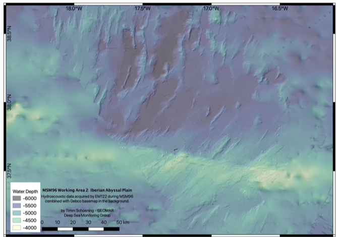
The southern “Iberian Abyssal Plain” area is located right North of the “Gloria Fracture Zone”. This is the fracture zone separating the European and African plates. The hydro-acoustic map of this area shows narrow and steep valleys in the North-West section, also mainly in a North-South direction as in PAP. Towards the West, wider and up to 6000m deep plains exist and the fracture zone itself lies to the South which is rising up to 2500m above the plains we sampled. The geochemical analyses on board revealed oxic to suboxic conditions in the area and the same set of analyses as for the PAP area will follow later.
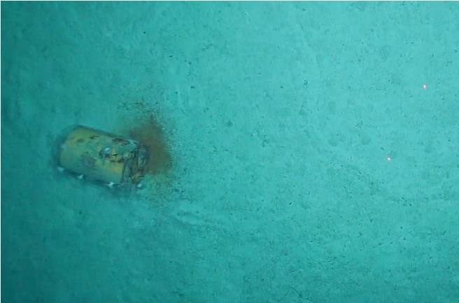
The limited image data of both areas seems to show varying frequencies of fauna with generally the same groups appearing but with apparent differences between deployment sites. Due to the small size of the image dataset, statistically robust image analyses will anyhow not be possible. What we have seen though in these deep and remote parts in the anthropogenic impact by finding litter on the seafloor: mainly plastics, occasionally glass bottles and one yellow barrel that left us a bit worried.
We are now looking forward to the final week of the cruise, completing the sampling and filling the last sample containers while in parallel closing the last gaps in the hydroacoustic maps.
Greetings on behalf of the cruise participants!
Tag und Nacht
Neunzehn Tage nach Beginn des wissenschaftlichen Programms beenden wir gerade die 57. Station dieser Ausfahrt, bevor wir uns in der Nacht wieder der Kartierung widmen. Seit dem Verlassen der irischen AWZ am 13. Oktober haben wir insgesamt bereits 2950 Seemeilen (ca. 5460 km) in internationalen Gewässern zurückgelegt. Wir haben die CTD dreimal eingesetzt, um Schallgeschwindigkeitsprofile und Wasserproben zu erhalten. Zweimal haben wir das OFOS eingesetzt, um hochauflösende Bilder des Meeresbodens zu gewinnen. Und wir haben den Multicorer 26 Mal eingesetzt sowie 17 hydroakustische Stationen durchgeführt. Die neun fehlenden Stationen sind diejenigen, die die Herausforderungen der Tiefseeforschung darstellen, und das sind diejenigen, bei denen es uns trotz unserer besten Bemühungen nicht gelungen ist, Proben oder Daten zu erhalten. Ungeachtet dessen gehen die gewonnenen Daten weit über das bloße Minimum hinaus, das wir uns erhofft hatten. Dieser Erfolg ist nur möglich, weil das Schiff, die Besatzung und die Wissenschaftler Tag und Nacht im Einsatz waren.
Aufgrund technischer Schwierigkeiten des OFOS und des Tiefseekabels – was uns schließlich dazu veranlasst hat, die Bildgebungs ganz aufzugeben und uns nur auf die Probenahme und Kartierung zu beschränken – wird sich die kommende Dateninterpretation nur auf hydroakustische und Labordaten stützen müssen. Da jedoch viele OFOS-Stationen abgekürzt wurden, war der Kartierungsteil dieser Fahrt tatsächlich weitaus effektiver als geplant. Wir hatten uns zum Ziel gesetzt, 170 Stunden mit der Erstellung hydroakustischer Karten zu verbringen und haben bereits mehr als 280 Stunden damit verbracht, weitere zu erstellen. Das daraus resultierende Gebiet – von dem der größte Teil zum ersten Mal in hoher Auflösung zur freien Verwendung in der Wissenschaft kartiert wurde – beträgt 56.000 Quadratkilometer. Dies entspricht in etwa der Fläche von Nordrhein-Westfalen und Hessen zusammen oder der Gesamtfläche von Kroatien. Da wir zwei Zielgebiete mit unterschiedlicher Tiefe, Breitengrad und Entfernung zum Kontinent beprobt und untersucht haben, fanden wir – wie erwartet und angestrebt – recht unterschiedliche Bedingungen vor.
Das nördliche Gebiet “Porcupine Abyssal Plain” besteht hauptsächlich aus flachem Meeresboden mit Neigungen von weniger als einem Grad bei einer mittleren Tiefe von ca. 4800 Metern. Das Gebiet wird zusätzlich von in Nord-Süd-Richtung verlaufenden Hügelrücken bedeckt, die sich bis zu 600 Meter über die Ebene erheben. Ein breiterer Seamount in dem Gebiet erhebt sich sogar bis zu 1000 Meter über die Ebene. In diesem Gebiet ergaben die Multicorer-Probenahme und die Porenwasseranalyse suboxische Bedingungen. Weitere geochemische Daten über den Gehalt an organischem Gesamtkohlenstoff, die Konzentration an gelöstem organischem Kohlenstoff, Nährstoffe, Porosität, Spurenmetalle, insbesondere Seltene Erden und das Neodym-Isotopen-Verhältnis – alles in der festen Phase und im Porenwasser – werden nach der Fahrt im heimischen Labor an Land gemessen.
Das südliche Gebiet der “Iberian Abyssal Plain” liegt direkt nördlich der “Gloria-Bruchzone”. Dies ist die Bruchzone, die die europäische und die afrikanische Platte trennt. Die hydroakustische Karte dieses Gebietes zeigt enge und steile Täler im nordwestlichen Abschnitt, ebenfalls hauptsächlich in Nord-Süd-Richtung wie in PAP und bei etwa 5300 Meter Wassertiefe. Nach Westen hin gibt es breitere und bis zu 6000 m tiefe Ebenen, und im Süden liegt die eigentliche Bruchzone, die sich bis zu 2500 m über die von uns beprobten Ebenen erhebt. Die geochemischen Analysen an Bord ergaben oxische bis suboxische Bedingungen in dem Gebiet, und die gleiche Reihe von Analysen wie für das PAP-Gebiet folgt später an Land.
Die wenigen Bilddaten beider Gebiete scheinen unterschiedliche Häufigkeiten der Fauna zu zeigen, wobei im Allgemeinen die gleichen Gruppen auftreten, jedoch mit offensichtlichen Unterschieden zwischen den jeweiligen Tauchgängen. Aufgrund der geringen Größe des Bilddatensatzes werden statistisch robuste Bildanalysen jedoch leider nicht möglich sein. Wir haben aber auch in diesen tiefen und abgelegenen Gebieten anthropogene Einwirkungen in Form von Müll am Meeresboden feststellen können: hauptsächlich Plastik, gelegentlich Glasflaschen und ein gelbes Fass, das uns etwas beunruhigt hat.
Wir freuen uns nun auf die letzte Woche der Reise, in der wir die Probenahme abschließen und die letzten Probenbehälter füllen und parallel dazu die letzten Lücken in den hydroakustischen Karten schließen werden.