Dear interested reader, family, colleagues and friends,
we are the geologists (“The Kardashians of science” ~ Dr. Sheldon Cooper) on board during this Meteor expedition in the Atlantic Ocean. May you heard already that oceanic crust is built along the mid-ocean ridges – the longest volcanic mountain chain on our planet. Over time, the newly formed crust is transported away from the ridges, matures and becomes covered by a lot of sediments. Intraplate volcanism connected to hot spots and mantle plumes can produce large volcanic provinces. Apart from that, it is believed that from its construction to its destruction (in subduction zones) oceanic crust is pretty boring and barely any volcanically activity occurs there.
But is that really true? In 2016, we sailed (basically we do that a lot) across a 20 Million years old part of the Atlantic Ocean and found something that looked weird. In the acoustic signals (our tool to map the seafloor 4000 m under the surface of the sea), we found large flat areas that were barely covered by sediments. We interpreted that as a sign of recent (much younger than 20 Million years old) volcanic activity!
We are here to confirm our hypothesis that even old and assumed to be inactive crust of the Atlantic Ocean has been overflown by young lavas. We want to find out if our interpretation of the acoustic signals representing young lava flows was correct. If this is the case, we would like to know when these eruptions took place, why they occurred, what triggered them and how much lava came out.
Over the last two weeks, we awaited with anticipation and daily growing excitement to reach our working area. Finally, in the early morning of the 23rd of July we deployed the OFOS (Ocean Floor Observation System) equipped with high-definition video camera to a depth of 4000 m to receive real-time footage of the seafloor (Image 1). We spent an exciting 12 hours watching OFOS flying over an amazing volcanic terrain on the seafloor (Image 2). We left the OFOS lab with wide smiles on our faces as we realized our hypothesis was correct!
Our next endeavour was to collect rock samples to find out the age and the origin of the lavas. To do that, we used a so called dredge that collects rocks from the seafloor (Image 4,5). These rocks will tell us their story as we will analyse them back in our labs in GEOMAR, Kiel (Image 6).
The rest of the time on Meteor, we are mapping the seafloor. Even though we are geologists, we will support our colleagues on their next station with the seafloor observation and sampling.
Sincerely yours,
Us Geologists
–
Liebe interessierte Leser, Familien, Kollegen und Freunde,
wir sind die Geologen (die Kardashians der Wissenschaft ~ Dr. Sheldon Cooper) an Bord dieser Meteor-Expedition im Atlantischen Ozean. Wie Sie vielleicht wissen, wird ozeanische Kruste entlang der mittelozeanischen Rücken gebildet – dem längsten vulkanischen Gebirgszug unseres Planeten. Mit der Zeit entfernt sich die neu gebildete Kruste von den aktiven Rücken, altert und wird von Sedimenten bedeckt. Intraplatten-Vulkanismus in Verbindung mit ‚Hot Spots’ und Mantelplumes kann große Vulkangebiete erzeugen. Davon abgesehen wird allgemein angenommen, dass ozeanische Kruste von der Entstehung bis zur Zerstörung (in Subduktionszonen) relativ langweilig und nur mäßig von vulkanischer Aktivität bestimmt ist.
Aber ist das wirklich wahr? Während einer Schiffsexpedition im Jahr 2016 (ja, wir machen so etwas oft) über einen 20 Millionen Jahre alten Abschnitt des Atlantischen Ozeans fanden wir Areale deren Aussehen merkwürdig erschienen. Über akustische Signale (das Werkzeug, mit dem wir den Ozeanboden 4000 m unterhalb des Meeresspiegels kartieren können) fanden wir große, flache Bereiche welche nur in geringem Maß mit Sediment bedeckt sind. Dies interpretierten wir als ein Zeichen von rezenter, deutlich jünger als 20 Millionen Jahren alter vulkanischer Aktivität!
Nun sind wir hier, um unsere Hypothese zu bestätigen, dass auch alte, inaktiv scheinende Atlantische Kruste von jungen Lavaströmen überflossen sein kann. Wir wollen herausfinden, ob unsere Interpretation der akustischen Signale korrekt ist und diese Signale junge Lavaströme repräsentieren. Wenn das der Fall ist, möchten wir herausfinden, wann und warum diese Eruptionen stattfanden, was sie angetrieben hat, und wie viel Lava ausgeströmt ist.
Während der letzten zwei Wochen stiegen unsere Erwartungen und Vorfreude, unser Arbeitsgebiet zu erreichen. Endlich, am frühen Morgen des 23. Juli ließen wir unser OFOS (Ozeanboden-Observierungssystem), ausgestattet mit einer hochauflösenden Videokamera in eine Tiefe von 4000 m, um Live-Aufnahmen des Meeresbodens zu empfangen (Bild 1). Nach 12 aufregenden Stunden, in denen wir Videobilder von tollen vulkanischen Strukturen sahen, verließen wir das Observierungslabor mit breitgrinsenden Gesichtern – Hypothese bestätigt (Bild 2)!
Unsere nächste Aufgabe bestand darin, Gesteinsproben zu sammeln, um das Alter und die Herkunft der Lava bestimmen zu können. Dazu benutzten wir eine sogenannte Dredge, ein einfaches Gerät zur Gesteinsbeprobung (Bild 4,5). Die gesammelten Gesteinsproben werden uns ihre Geheimnisse offenbaren, aber erst nach den folgenden Untersuchungen in unseren Laboren am GEOMAR, Kiel (Bild 6). Während unserer weiteren Zeit an Bord der Meteor werden wir den Meeresboden weiterkartieren und unterstützen unsere Kollegen bei ihrer nächsten Station mit OFOS-Observierung und Meeresboden-Beprobung.
Viele Grüße,
Wir Geologen
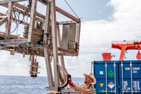
Image 1 | The OFOS (Ocean Floor Observation System) equipped with a high-definition video camera to receive real-time footage of the seafloor. (Photo: Johannes Werner)
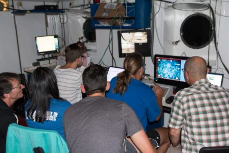
Image 2 | Spending an exciting 12 hours watching OFOS flying over an amazing volcanic terrain on the seafloor. (Photo: Johannes Werner)
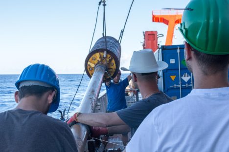
Image 3 | The gravity corer is used to sample the seafloor. (Photo: Johannes Werner)
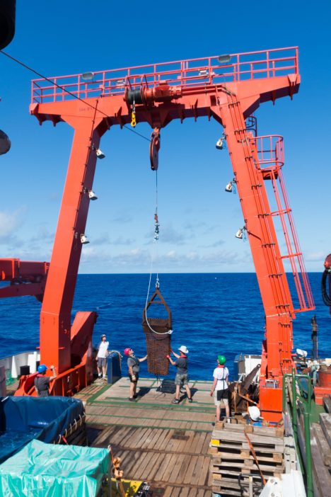
Image 4 | The “dredge” is used to collect rocks from the seafloor. These rocks will tell us their story as we will analyse them back in our labs in the GEOMAR, Kiel. (Photo: Johannes Werner)
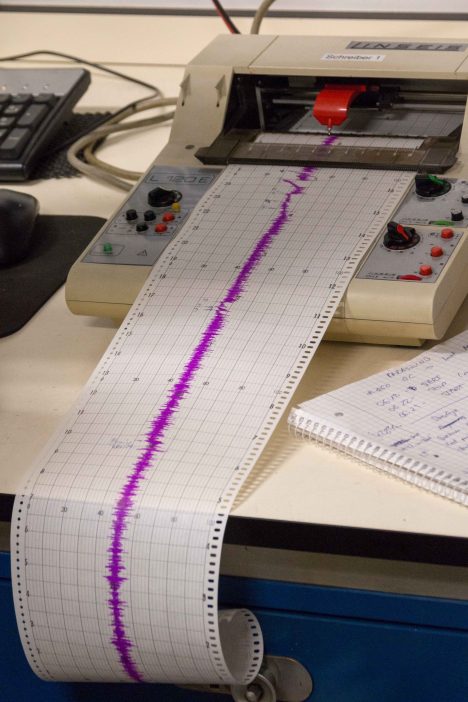
Image 5 | The force being applied to the dredge can be measured in real-time while the device is used. Peaks potentially show that the dredge is sampling rocks. (Photo: Johannes Werner)
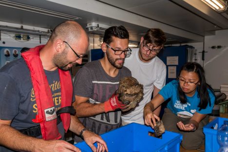
Image 6 | The dredge collected stones, which will be analyzed in the labs of the GEOMAR, Kiel. (Photo: Johannes Werner)
Hallo liebe Geologen!
Das hört sich nach interessanten neuen Erkenntnissen zu unserem schönen Planeten an – und nach einem prächtigen Erfolg für Euch.
Prima, prima !!!
Vielen Dank, liebe Kardashians 😉 für die Informationen aus den Tiefen des Atlantiks und von Bord der Meteor.
Viel Erfolg und viel Spaß weiterhin!
Norbert und Christiane Ahlers