—english version below—
Liebe Leserinnen und Leser,
hier sind wieder eure LieblingswissenschaftlerInnen von SO252. Wir haben inzwischen unser Messgebiet vor Ritter Island in der Bismarck See erreicht und sammeln fleißig hydroakustische und seismische Daten.
Doch bevor wir über die eigentliche Arbeit berichten, möchten wir euch auf den aktuellen Stand unserer außerwissenschaftlichen Aktivitäten bringen:
Die Vorrunden des Tischtennis-Turniers laufen auf Hochtouren – aktuell führend in den Vorrunden:
Team Judith & Joel und Team Aaron & Hans (wir sehen uns in der Endrunde!)
Es bleibt also spannend!
Außerdem haben wir uns die Transitzeit mit einem „Mörder-Detektivspiel“ vertrieben. Der „Mörder“ ist noch auf freiem Fuß und hat mittlerweile den Großteil der Wissenschaftler umbringen können. Auch sämtliche Blog-Autoren haben bis dato nicht überlebt – mehr dazu, wenn der „Mörder“ enttarnt ist.
(Vielleicht doch noch mal eine Nachricht aus dem Grab: Mich mit den Worten „i want to show you something“ ins Labor zu locken, um mich zu töten, ist ganz schön fies. Ganz. Schön. FIES!)
Um mal wieder ein wenig wissenschaftlicher zu werden: Momentan fahren wir ein Raster oberhalb der Rutschung der kollabierten Vulkaninsel Ritter Island ab und nehmen Daten mit verschiedenen Messgeräten auf. Eines dieser Geräte, den sog. Multibeam Echosounder (dt.: Fächerecholot), möchten wir euch nun vorstellen.
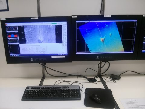
Multibeam me up, Scottie: Diese Bilder liefert uns das hochmoderne Multibeam-Gerät direkt. /
(Multi) beam me up, Scottie. This is what comes directly from the ultramodern multibeam echosounder system.
Das Multibeam-System liefert uns ein topographisches Abbild des Meeresbodens, sowie Wassersäulen Daten, mit denen man u.A. Gasaustritte aus dem Meeresboden feststellen und kartieren kann.
Ein Fächerlot beruht auf dem Prinzip der akustischen Rückstreuung. Wir erzeugen dabei unterhalb des Schiffs eine Schallwelle, die am Meeresboden zurückgestreut und von den Sensoren am Rumpf des Schiffes empfangen wird. Aus der Zeit, die das Signal vom Schiff zum Meeresboden und wieder zurück zum Schiff braucht (die sogenannte Two-Way-Traveltime – dt.: Zwei-Weg-Laufzeit) berechnet der Computer die Wassertiefe an den vom Signal abgedeckten Punkten und daraus durch Zusammenfügen aller Daten die Topographie des Meeresbodens. Außerdem nutzt das Gerät die Intensität des rückgestreuten Signals, um die Eigenschaften des Meeresbodens besser zu verstehen. Wir erhalten als Ergebnis dann u.A. eine schöne, bunte Karte des Meeresbodens. Klasse, oder?
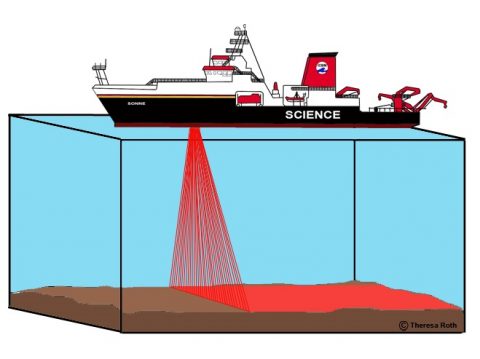
Prinzip des Fächerecholots. / How a multibeam works.
Das Signal wird übrigens in mehreren Strahlen, die jeweils in einem festen Winkel zueinander verlaufen, nach unten gestrahlt. So ergibt sich ein Fächer, der bei der Fahrt über die See einen breiten Streifen des Meeresbodens erfassen kann – daher auch der Name Fächerecholot.
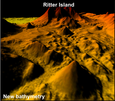
Nicht der Mars, sondern der Meeresgrund. /
Not Mars – this is the ocean floor.
Wir befinden uns in der glücklichen Situation, auf der FS SONNE über neuste Technologie zu verfügen. Das sorgt dafür, dass wir nicht nur sehr stabil (meistens sogar ohne den Wellengang zu spüren!) übers Wasser dampfen, sondern mit dem hochmodernen Multibeam-Gerät eine sehr gute Auflösung unserer Meeresboden-Karte bekommen.
Das war‘s erst mal wieder von uns, irgendwann müssen wir hier schließlich auch noch Tischtennis spielen und aufm Sonnendeck liegen arbeiten.
On the next episode of SO252: Mord, Intrigen und Roboterpandas mit Laseraugen. Nicht verpassen!
Soweit erstmal,
eure WissenschaftlerInnen von SO252
Autoren: Theresa Roth, Michel Kühn
Multibeam-Karte: Christian Berndt
Zeichnung: Theresa Roth
—english version—
Dear Readers,
It’s your favourite scientists from SO252 again. In the meantime we have reached our survey area at Ritter Island in the Bismarck Sea and are furiously collecting hydroacustic and seismic data.
But before we tell you all about our work, we’d like to update you on our extra-curricular activities: The first rounds of the international table tennis competition are in full swing – currently in the lead:
Team Judith and Joel and Team Aaron and Hans (see you in the finals!)
It remains an exciting competition!
We also kept ourselves busy during our transit with a “murder mystery” game. The “murderer” is still out there and has successfully done away with a large part of the science team, including the entire blog team – we will tell you more when the murderer has been revealed.
(Allow me a quick message from beyond: Saying “I want to show you something” to get a person to follow you into the lab, so that you can bump them off is really VERY mean!)
Let’s get a little more scientific: At the moment we are completing a grid above the landslide mass of the collapsed volcanic island Ritter. We are collecting data on a number of instruments at the same time. One of these is the so-called multibeam echosounder, which we’d like to introduce to you in this installment.
The multibeam system creates a topographic image of the ocean floor. It also collects data about the water column with which you could find and map out a number of interesting features, for example, gas emissions from the ground.
The multibeam uses the principal of acoustic backscattering: This system is repeatedly creating a soundwave underneath the ship, this is reflected off the ocean floor and then received by sensors on the hull of the ship. A computer calculates the water depth from the time the signal requires to travel from the ship to the ocean and back again (that’s called the “two-way travel time”). Data is collected from all the points that the signal is returned from and then merged by the computer to create the topography of the ocean floor. The multibeam also uses the intensity of the backscatter signal to better understand the properties of the ocean floor (for example its roughness). The result we get is, amongst other things, a beautiful and usually colourful image of the ocean floor – fantastic isn’t it?
The multibeam signal is emitted in multiple beams (yup, they did a good job naming it!) which are at constant angles to each other, producing a fan of signals that can cover a wide swath of the ocean floor as we move along. (That’s why our German friends also call it a Fächerecholot which translates literally as fan-echosounder).
On board the RV Sonne, we are lucky to have access to the latest technology. This not only means that our ship is sailing extremely evenly, in fact usually you cannot feel waves at all, but also that we have very good resolution on our ocean floor maps.
That was all for this time folks, we have to get on with playing table tennis and tanning on the upper deck work, now.
Coming soon on SO252: Murder, intrigues and robot pandas with laser eyes. Don’t miss it!
Bye for now!
Your SO252 scientists
Authors: Theresa Roth, Michel Kühn
Fotos: Michel Kühn
Multibeam map: Christian Berndt
Drawing: Theresa Roth
Translation: Melanie Ray
No English translation this time? R/V Langseth followers are loving the blogs!
english version is coming soon 🙂
Hi Translator here,
Glad to here the translations are being used! I promise there will be a translation of every blog while we are at sea But the English version comes a bit later because I get the texts after the German ones go online. Sorry for the delays, but if you come back later the translation should be there already. Ahoy! Melanie
schön.wieder von euch zu hören,gruß an meine enkelin theresa
günter roth
Mit der Kraft des mir verliehenen Amtes: Grüße zurück!