—english version below—
Liebe Leserinnen und Leser,
eure Wissenschaftler von SO252 konnten den Angriff der pandimensionalen Monster aus dem Portal im Marianengraben erfolgreich abwehren. Puh!
Das ist natürlich Unfug (das Portal wurde bereits 2012 von James Cameron geschlossen), allerdings verbrachten wir die letzten 48 Stunden tatsächlich oberhalb des Challengertiefs, das mit seiner Lage ca. 11 km unterhalb des Meeresspiegels als tiefster Punkt der Erde gilt. Gespannt verfolgten einige der Wissenschaftler die Tiefenanzeige an Deck des Schiffs bei der Annäherung an die angestrebte Position – selbstverständlich nicht ohne „oooh“s, „aaaah“‘s und Jubelrufe beim Überschreiten der 10000 m-Marke. Wann hat man schon mal so viel Wasser unter sich?
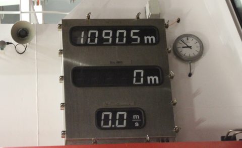
Schon recht tief: Challengertief. / kind of deep: Challenger Deep.
Auf Position führten wir mit dem Ozeanographen Hans zwei CTD (Conductivity, Temperature, Depth)-Messungen in Tiefen bis 8000 m und 10900 m durch. Zwei Messungen waren nötig, da der Drucksensor des Messgerätes über 8000 m Wassertiefe eingeholt, deaktiviert und mit einer Schutzkappe versehen werden musste, um nicht beschädigt zu werden. Nach 14 Stunden waren die Messungen abgeschlossen und Hans konnte endlich seine Mooring (wir betonen es gerne noch einmal, weil es sich sehr krass anhört: die TIEFSTE und LÄNGSTE Mooring, die je ausgebracht wurde) ausbringen. Nebenbei wurden von unseren GeophysikerInnen im hydroakustischen Labor der SONNE auch bathymetrische Daten, also Daten zur Abbildung der Topographie des Meeresbodens, vom Challengertief gesammelt.
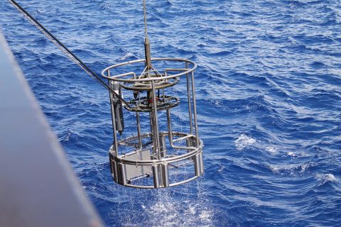
Hat noch ein paar Meter vor sich: CTD. / Nearly there: CTD.
Die insgesamt etwa 7000 m lange Mooring (dt.: Verankerung) wird dort, in knapp 11000 m Wassertiefe, für einen Zeitraum von ein bis zwei Jahren Temperatur- und Strömungsdaten zur Untersuchung interner Wellen und Strömungen in der Tiefsee sammeln.
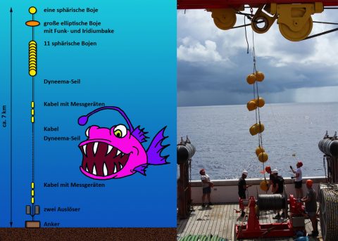
Mooring: Reale Gefahren (links) und Durchführung (rechts). /
Mooring: the plan and possible deep sea hazards (left), the 11 spherical buoys on their way out (right)
Das Aussetzen begann etwas mehr als 15 km von der eigentlichen Zielposition der Verankerung entfernt. Dort wurde zuerst die obere Boje des Systems und dann bei einer Geschwindigkeit von 1-2 kn der Messschlauch/die Messkabel ausgesetzt. Zum Schluss wurde an der exakten Position das untere Ende (ein über 650 kg schweres Gewicht) ausgesetzt. Dieses Gewicht zog die zuvor an der Wasseroberfläche ausgesetzten 7 km Kabel und Schläuche mit in die Tiefe, sodass die gesamte Mooring nun oberhalb des Gewichts senkrecht im Wasser stehen sollte.
[Ihr hättet Hans Gesicht sehen sollen, als die Mooring letztendlich ausgesetzt war. Als wäre ein 650 kg schweres Eisengewicht von ihm abgefallen. Was ja auch passiert ist. Fantastisch!]
Uns bleibt nun nur Hans die Daumen zu drücken, dass kein pandimensionales Tiefseemonster (oder etwas völlig Normales) seine Mooring anknabbert.
You like to? Moor it!
Wir befinden uns nun wieder auf Transit in unser Messgebiet Ritter Island – dort sollten wir am Nachmittag des 15.11. eintreffen.
Bis dahin lassen wir aber noch mal von uns hören.
On the next episode of SO252: Meerjungfrauen, Atlantis und der gefährlichste Job Alaskas.
Soweit und viele Grüße in den Schnee,
eure Wissenschaftler von SO252
Autoren: Michel Kühn, Theresa Roth, Bettina Schramm
Fotos: Anne Völsch, Melanie Ray
Zeichnung: Theresa Roth
Übersetzung: Melanie Ray
—english version—
Dear Readers,
Your SO252 scientists were able to fight off the pan-dimensional beast that came through the Mariannas Trench space-time discontinuity portal. Phew! Just kidding – everyone knows the portal was already closed by James Cameron in 2012.
However, we did spend the last 48 hours above the Challenger Deep, the deepest known point on Earth where the ocean floor is around 11km below the surface of the ocean. A good few of the scientists expectantly watched the depth meter on deck as we got closer to our planned position – of course there was plenty of ooh-ing and ah-ing and cheering as the 10,000m mark was surpassed. When are you likely to be floating above quite so much water again?
From this position we, and our Oceanographer Hans, completed two CDT (Conductivity, Temperature, Depth) surveys; one down to 8000m and then a second to 10,900m. Two surveys were required because the pressure sensor had to be brought back in, deactivated and covered with a protective cap when it reached 8000m, so that it would not be damaged as the CDT went further down. After 14 hours, CDT these measurements were completed and Hans could finally put out his mooring (and let us just mention again it is the DEEPEST and LONGEST mooring that has ever been put in the ocean!). At the same time, our geophysists in the Sonne hydroacustics lab were collecting bathymetric data of the Challenger Deep, that is data that visualizes the topography of the ocean floor.
The mooring (instruments that are anchored to the seafloor), has a total length of about 7000m and will be collecting temperature and current data at just under 11,000m water depth for 2 years (!). The analysis of this data will give us information about internal waves and currents in the deep sea.
We began putting out the mooring at around 15km from its actual designated final position. Here the upper buoy of the system was lowered into the ocean, then cables with the measuring equipment attached began to slowly unwind into the ocean as the ship moved away at around 1-2 knots. Finally, a more than 650kg weight was released into the ocean, this pulled the 7km of cable and wires that had been unwound by this point into an upright position in the deep, and at the exact planned position. (You should have seen Hans face when the mooring was finally completed. As if a 650kg weight had fallen from his shoulders. Which it actually kind of had – fantastic!)
We can only cross our fingers for Hans that no pan-dimensional deep sea monsters (or more run of the mill deep sea dwellers) chew at his mooring.
You like to? Moor it!
We are now back on our way to the area of interest around Ritter Island – we should arrive there in the afternoon of the 15th November.
But we will send another message before then.
Coming soon on SO252: Mermaids, Atlantis and the most dangerous job in Alaska.
That’s all folks – have fun with the snow in the northern hemisphere (if you have some)!
Your SO252 scientists
Authors: Michel Kühn, Theresa Roth, Bettina Schramm
Fotos: Anne Völsch, Melanie Ray
Translation: Melanie Ray
Cartoon: Theresa Roth
Liebe Wissenschaftler von SO252
Ein sehr schöner und interessanter Bericht. Vielen Dank
ich beneide euch günter roth
Ach ja, da steht ja für einige die Äquatortaufe an.
Hier ist der Schnee wech, aber es ist immer noch kalt -2/+2°
Großartig, es gibt sie also wirklich, diese “tiefste” Stelle 🙂
In Ausstellungen oder bei anderen Veranstaltungen werden wir ständig danach gefragt (zum Beispiel: http://www.oceanblogs.org/oceannavigator/2013/10/29/tag-der-deutschen-einheit-stuttgart-besucher-fragen-wissenschaftler-antworten-iv/) Aber jetzt haben wir das Beweisfoto.
Generell schließe ich mich meinem Vorkommentator Günter Roth an 🙂
Weiterhin gute Fahrt und viele Grüße aus dem winterlichen Kiel,
Jan